Karakoram Highway: Kashgar to the Roof of the World
One of the world's highest paved roads — through the Pamir Mountains, past a lake at 3,600m, through Tajik stone villages, to the Pakistan border at 4,700m.
The Karakoram Highway (KKH) is the highest paved international road in the world, connecting Kashgar, China to Islamabad, Pakistan. The Chinese side — from Kashgar to Khunjerab Pass — is roughly 400 km of increasingly dramatic scenery: red sandstone canyons give way to sand dunes, then snow-capped 7,000m peaks of the Pamir and Kunlun ranges. This is the route that ancient Silk Road traders took, and the landscape has barely changed.
Highlights
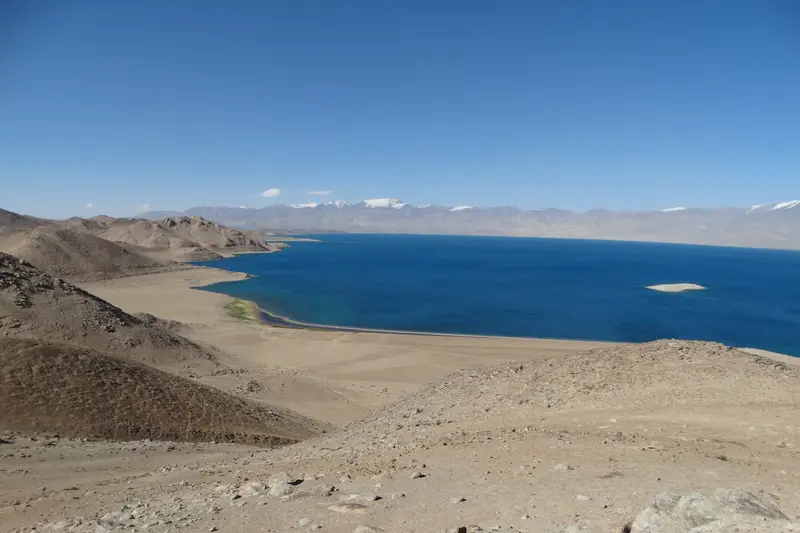
Karakul Lake
A shockingly blue alpine lake at 3,600m with the 7,546m Muztagh Ata reflected in its surface.
Tajik Tashkurgan
A stone-built Tajik town with a 1,300-year-old fortress, poplar-lined streets, and yaks grazing in the grasslands.
Khunjerab Pass
Stand at 4,700m on the Pakistan border — snow-covered peaks in every direction, one of the highest paved roads on earth.
The Drive Itself
Red sandstone canyons give way to sand dunes, then 7,000m peaks — 400 km of the most dramatic road in China.
Day-by-Day Itinerary
Kashgar
Arrive in Kashgar (fly from Urumqi). Spend the day acclimatising and exploring the Old City. The Id Kah Mosque, Apak Khoja Mausoleum, and the labyrinthine alleys of the old town are all walkable. In the evening, eat at the night market — the lamb kebabs (kawap) here are the best in China. Arrange a driver for tomorrow morning through your hotel or a local agency.
Book your driver the night before. A private car with driver for the KKH is the only practical option — your driver will handle the police checkpoint registrations, which you cannot do yourself.
Kashgar to Karakul Lake
Leave Kashgar early (7am). The first 80 km are flat desert, then the road climbs through the Gez River canyon — red sandstone cliffs on both sides. At the Opal checkpoint, your driver registers with the police (30-45 min). After the checkpoint, the valley opens up and you see your first snow peaks. By early afternoon you reach Karakul Lake at 3,600m — a shockingly blue alpine lake with Muztagh Ata (7,546m) reflected in its surface. Stay overnight in a Kyrgyz yurt camp on the lake shore.
The yurt camps have no heating and temperatures drop to near freezing even in summer. Bring a warm sleeping bag. There is no running water — wet wipes are your friend.
Karakul to Tashkurgan
Morning at Karakul Lake — walk the shoreline, photograph the sunrise on Muztagh Ata, and visit the Kyrgyz herder families who live here year-round. Midday, continue south to Tashkurgan (Tajik Autonomous County). The road crosses the 4,100m Subash Pass, then descends into the Tashkurgan Valley. Tashkurgan is a Tajik-majority town with stone houses, poplar-lined streets, and a 1,300-year-old stone fortress. Spend two nights here to acclimatise before the pass. Visit the Stone Fortress, the Tajik museum, and the grasslands outside town where yaks graze.
Tashkurgan is at 3,100m — you will feel the altitude. Walk slowly, drink water constantly, and avoid alcohol.
Khunjerab Pass & Return
Leave Tashkurgan at 7am for Khunjerab Pass (125 km, 2.5 hrs). The road climbs steadily past grazing yaks and occasional camel herds. At the pass (4,700m), you are standing at the Pakistan border — snow-covered peaks in every direction. There is a Chinese border post with a large sign for photos. Spend 30-45 minutes (longer and the altitude hits hard), then drive back to Tashkurgan for the night or push through to Kashgar if you are short on time.
The pass is open May-November. Even in July, temperatures at the pass are around 5-10°C. Bring a down jacket. The border police may deny access without warning due to military activity — your driver will know before you leave Tashkurgan.
Planning This Route
Altitude & Safety
This route goes from 1,300m to 4,700m. Acute Mountain Sickness (AMS) is a real risk above 3,500m. Symptoms include headache, nausea, and shortness of breath. The best prevention: spend 2 nights at Karakul (3,600m) before going to Khunjerab (4,700m). Diamox (acetazolamide) helps but requires a prescription. If symptoms worsen, descend immediately — Tashkurgan is 400m lower than Karakul and Kashgar is at 1,300m.
Permits & Paperwork
Your driver handles most paperwork. You need your passport and Chinese visa (or visa-free entry proof). At the Gez checkpoint, police register your entry to the border zone — this is routine and takes 30-45 minutes. No special permit is required for foreign tourists on the KKH as of 2026, but rules can change. Your hotel or driver will know the current situation.
Internet & Connectivity
Mobile signal is patchy beyond Karakul Lake. Download offline maps before leaving Kashgar. An international eSIM (see our eSIM guide) is the most reliable option — it routes through Singapore or Hong Kong. A VPN is essential for Kashgar hotel WiFi.
Every Karakoram journey we design is tailored to your pace and comfort level. Tell us how you like to travel, and we'll craft an itinerary that's yours alone.
Ready to Plan Your China Journey?
Tell us about your dream trip. We will send you a personalized proposal — no obligation, no pressure.
Or call us: +44 20 XXXX XXXX